Tuesday, March 29, 2016

Texas Full of Tokyo's


Take the expansive space of Texas with its iconic shape, then overlay into that the most dense city in the world. An experiment of a densely populated the area and let’s see what comes of this.

East & West collide. Many notions of both places can be construed. If you were to take these opposing mindsets and work them together what could happen?

Friday, March 25, 2016

USA & Tokyo Land Efficiency Model - Phase I

US & Tokyo Proportion Efficiency Map 1:200mi scale.
Thinking about the density of Tokyo and what it would be like to reduce our overall land footprint in the the United States to a microscopic level. I chose 10 locations to more than equal our population with a 25 year estimated advance in growth.

All living areas, cities that already have a dense population that can be migrated into the most efficient living centers - ziggurats that employ gardens and parks in proportion to each tower. With commercial areas for meeting and transportation centers to collect people at HyperLoop + This one too, hubs to easily get to specific work and recreational zones located around the U.S.

We currently have developed less than 5% of our land, but with focused density we could cut this by a factor of 100. Then use more open space for recreation and leisure. Also, by focusing our
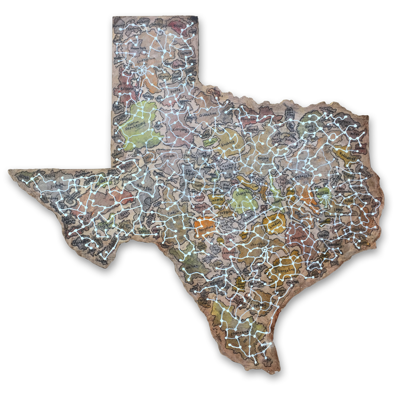
agricultural and manufacturing to more efficient locations and geographic relationships we would gain a very powerful use of land.

ziggurat city plan based on .5 mile grid.
This is very science fiction, but we are at a critical place in time where this type of thinking is required. This is only Phase I because I see this as a model that should be reproduced throughout the world.

ziggurat close up showing terraces
We can start to be more efficient with how we handle our water,
energy needs, food, living environment, daily regimen of exercise, human interaction and social connectedness.

Other Research:

Live in a skyscraper:

Housing Projects

1 square mile project - utopian environment possible?

Water plan

Water / sewer potential

Food potential

Food handling, containers reuse, recycle:
--

Power potential

Travel


Clothing / Practical yet room for personal expression: Bamboo / Cotton

Outdoor Health, Recreation & Activities: see map

Vacations: see map

Arts:

Entertainment:

Employment:

Manufacturing: see map

Building Materials: see map

Spare Parts & Repairs: see map

Cemeteries:


Faiths:


Thursday, March 24, 2016

Babel 2.0

...Babel 2.0


*********

This is a concept for the larger rhombus stretched canvases that I have started. The final will be approx. 60" x 60"

This shows the layers I anticipate having in different applications. There will be digital printed canvases mixed with painted canvases + stenciled spray painted areas.
“If Necessity is the Mother of Invention, Then Technology is the Mother of Dependence.”
With the continued use of the rhombus shape I am questioning whether the shape lends itself to the idea of an underlying structure of science and math as an interlocking foundation for the inventive attempts at various technologies.

A form that gives us a look at a world where people strive to use new technologies with the hope that each one will make us incrementally more self-sufficient while seeking to be further distanced from a consideration of faith.


Thursday, March 3, 2016

In Progress Jan-Feb

If I Loose My Grip, Will I Take Flight?
Ex-Eden In Progress

RGB with Tools, Skull & Contract
Uniformity of Nature

Thursday, January 14, 2016

Texas-World

TEXASWORLD Plan
Acres in Texas: 171,904,640 
World Population: 6,602,224,175

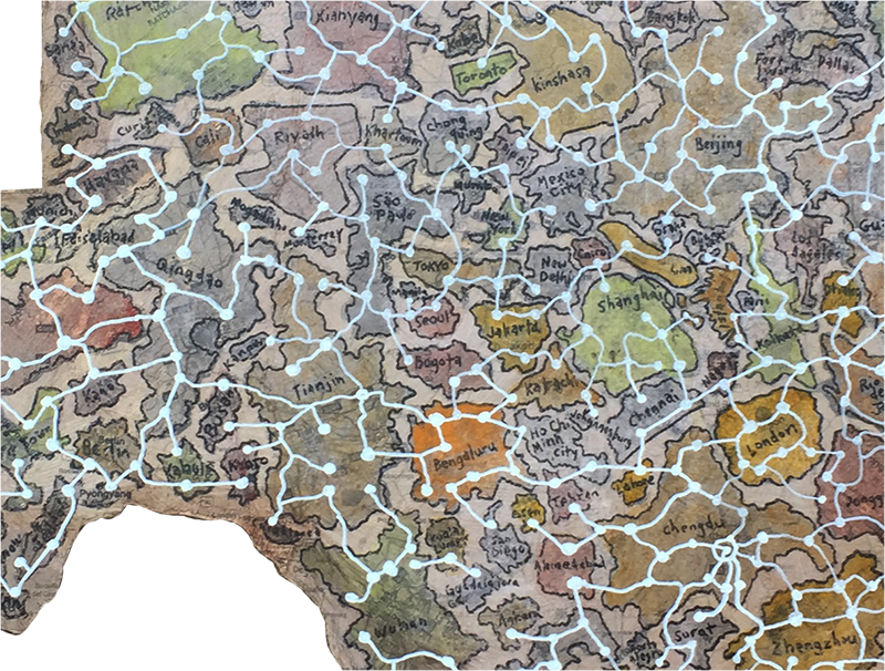
If the world was turned into a Monopoly® Game. How long would it take to become unbalanced again? Can we make everything even? Is equality a possibility? Let's give everyone the same access to food, shelter, etc., what would happen?

I mapped the 150 most populated world cities into the map of texas at 1:20miles. I found that so many cities have such a small footprint, while the largest cities in China occupy such large swatches of land it overwhelmed some of the space in the map. It was quite a contrast to see in front of me.

The exercise of connecting the cities with the white constellation reminds me of an internet that doesn't have to follow any particular geographical order, but can jump randomly in any direction.

The idea of having the iconic shape of Texas as the first thing you see give an impression of one type of mindset. In many ways the shape of Texas is as recognizable as the U.S. map. Texas also is an strange representation of a “typical American” so it seems appropriate to use this shape as a generalization of our society.

Also, Texas having flown under six different country flags also seems to be a kind of reminder of the history of the state.

Friday, December 18, 2015

Refugees of Eden


Refugees of Eden. Those escaping a now dead tree. This is a "serious doodle" based on an idea I had while all of the debates regarding the Syrian refugees were trying to find new countries to escape to.
A land that was once home, is now no longer hospitable. Now their new reality is a cold, hard land of un-receptive people that see them as inconveniences.

Tuesday, December 15, 2015

Hidden Decoy

An oxymoron. A decoy that would lead an unsuspecting duck to its demise. The surface now being camouflaged obscures its intent. This being both something to attract and hide is a curious combination.
It's a mixed-metaphor and begs a question of the purpose. Many times we are attracted to dangerous situations and do not see them coming.
The camouflage style being of the digital style adds another layer to the idea and the hand-painted application can bring yet other layers of questioning.